News

Discovery Map Series: 039 Father of Waters 1887...
This reproduction of a rare Mississippi River "ribbon map" was drawn by Captain Willard Glazier to "prove" his premise that the True Source of the Mississippi was Lake Glazier rather...
Discovery Map Series: 039 Father of Waters 1887...
This reproduction of a rare Mississippi River "ribbon map" was drawn by Captain Willard Glazier to "prove" his premise that the True Source of the Mississippi was Lake Glazier rather...

Discovery Map Series: 147 Zachary Taylor's Seat...
This map was produced by the United States Bureau of topographical engineers in the year 1839. It was produced at the order of Brvt. Brig. General Z. Taylor depicting the territory of...
Discovery Map Series: 147 Zachary Taylor's Seat...
This map was produced by the United States Bureau of topographical engineers in the year 1839. It was produced at the order of Brvt. Brig. General Z. Taylor depicting the territory of...

Discovery Map Series: 026 Carte De La Louisiane...
De L'Isle's "Carte de la Louisiane" published in approximately 1731 would become the primary reference source for exploration of the Mississippi and Missouri river valleys and was used by other...
Discovery Map Series: 026 Carte De La Louisiane...
De L'Isle's "Carte de la Louisiane" published in approximately 1731 would become the primary reference source for exploration of the Mississippi and Missouri river valleys and was used by other...

Educational Map Series: The Seminole War Era Map
Secretary of War John Joseph Poinset commissioned this map to be made by Washington Hood in 1838. Incidentally, the Christmas plant we know as the Poinsettia gets its name from...
Educational Map Series: The Seminole War Era Map
Secretary of War John Joseph Poinset commissioned this map to be made by Washington Hood in 1838. Incidentally, the Christmas plant we know as the Poinsettia gets its name from...
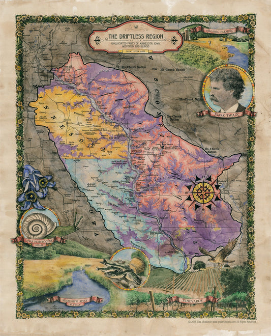
Travel Tuesday Map Feature: 148 The Driftless R...
The unglaciated region of western Wisconsin, northeastern Iowa, northwestern Illinois, and southeastern Minnesota is a natural and beautifully sculpted landscape that is known as the Driftless Area. The area is...
Travel Tuesday Map Feature: 148 The Driftless R...
The unglaciated region of western Wisconsin, northeastern Iowa, northwestern Illinois, and southeastern Minnesota is a natural and beautifully sculpted landscape that is known as the Driftless Area. The area is...